
Al-Faw: Reading an Ancient City and Its Oasis
Read Al-Faw through its city, oasis and trade setting, with verified heritage sources and practical ways to distinguish evidence across periods.
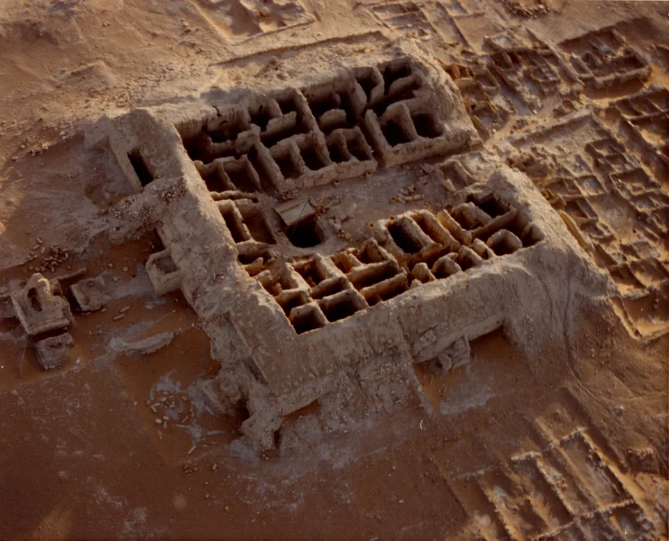

Al-Faw is best understood as a connected archaeological landscape: an ancient caravan city, its oasis and water infrastructure, and evidence from earlier periods around it. Qaryat al-Faw is the settlement within that wider setting. Treating the whole area as one building, or assigning one age to every visible remain, loses the relationships that make it interesting.
The Cultural Landscape of Al-Faw Archaeological Area entered the UNESCO World Heritage List in 2024. This guide explains how to read its settlement, water and trade evidence together. It is a cultural introduction, reviewed on 3 October 2026, rather than a current visitor itinerary. The historical photographs illustrate different scales of evidence; they do not establish today's access arrangements.
Locate Al-Faw beyond Riyadh city
Saudipedia's geographical account, dated 16 February 2023, places Al-Faw in Wadi ad-Dawasir Governorate, where the Tuwaiq mountain setting meets the western side of the Empty Quarter. Its approximate 700-kilometre relationship southwest of Riyadh is geographical orientation, not a verified road distance or driving time.
That distinction matters when browsing the site's Riyadh Region guide. An article in the same regional category as a capital-city museum may describe a very different location. A regional label helps organise knowledge; it cannot tell you whether two places fit into one afternoon.
For an initial reading, draw three boxes labelled settlement, oasis and surrounding landscape. Add a fourth box for the regional route network. This simple sketch prevents the city ruins from becoming the entire story. It also encourages useful questions about relationships before concentrating on individual objects.

Read the city and water system together
UNESCO's site record describes Qaryat al-Faw as a caravan relay connecting Najran with central and eastern Arabia. It identifies residential and commercial areas alongside an oasis with irrigation infrastructure and ancient plantation pits. The city and its agricultural support therefore belong in the same explanation.
Think about the tasks a settlement must solve: obtaining water, supporting everyday life and receiving people travelling through it. These are questions for interpreting the evidence, rather than a reconstruction of a particular household's routine. A room plan alone cannot tell you how all three tasks were organised.
In the aerial photograph, notice the arrangement of excavated spaces and the surrounding ground. Compare the scale of a room with the extent visible outside the complex. Avoid labelling each space a bedroom, store or shrine from its shape alone. A published excavation plan or authoritative interpretation is needed before giving it a specific function.
The useful comparison with Al-Ahsa's oasis landscape is the question of how settlement and water relate. It does not imply that the two places share the same chronology, surviving infrastructure or present-day activity. Keep each location's evidence separate.
Separate a long landscape history from the caravan city
UNESCO distinguishes prehistoric remains from the later caravan settlement and dates the city's abandonment to around the fifth century CE. Its account connects that abandonment with depletion of water resources. These statements describe different parts of a long history, rather than a single moment captured by all surviving material.
When a headline calls an archaeological area thousands of years old, ask which evidence it means. A stone tool, a tomb and an urban wall do not automatically belong to the same period. The date of an early human presence cannot be transferred to every later building in the area.
Try keeping a chronology note with three columns: evidence, attributed period and source. Leave the period blank when you only have an unlabelled photograph. If an official record describes the wider landscape but an object caption refers to one find, preserve that difference in your notes.
This approach makes uncertainty useful. Instead of repeating an impressive age without context, you can state that the landscape contains evidence from multiple periods, while a particular structure's date needs a more specific reference. That is a clearer account for another reader to check.
Move from the aerial view to a small object
Saudipedia's Qaryat al-Faw overview describes markets, houses, wells and other remains, as well as furnishings and artistic objects. Its page carries an original 28 January 2021 date and includes later information about the 2024 inscription. The initial page date should not be mistaken for the date of that later event.
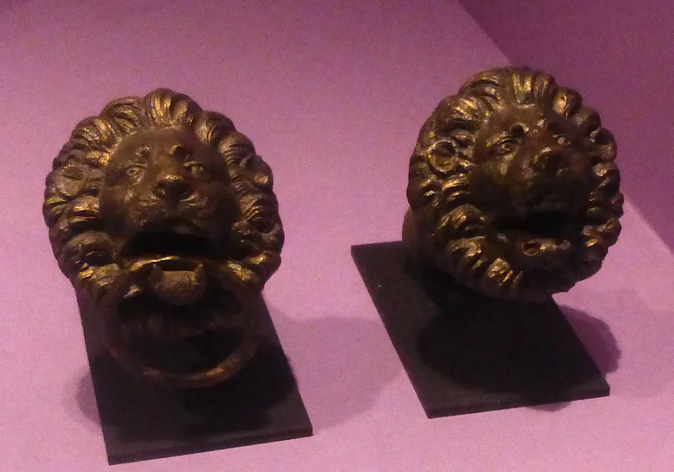
The second photograph shows a pair of lion-head door knockers identified by its source as from Qaryat al-Faw. Their faces, projecting forms and rings are visible. Those observations support a discussion of the object's appearance; they do not establish which doorway held them, who owned them or what every detail meant.
An object and a building plan answer different questions. The aerial view helps you consider spatial arrangement. A close photograph makes workmanship and small features easier to inspect. Neither is a substitute for an excavation record connecting a find to its original context.
If you later explore the Saudi National Museum through objects, use the same habit: record the object label, location of origin and stated date separately from your own observations. This article does not claim that these particular knockers are currently on display there.
Build a careful Al-Faw evidence note
A useful summary can be short while preserving the site's complexity. Start with its location and the distinction between Qaryat al-Faw and the wider cultural landscape. Then explain how city, oasis and routes belong together. Finish with the evidence limits that matter for the material you are discussing.
- Name the place and geographic scale before describing a feature.
- Separate a dated archaeological interpretation from something visible in a photograph.
- Attach an age to the relevant evidence, rather than to the entire landscape.
- Keep the source date, heritage-inscription year and image date distinct.
- Confirm current visitor arrangements independently before making travel plans.
For a final reading exercise, compare the two photographs and write one sentence about what each reveals, followed by one question it cannot answer. The result is a more informative introduction than a list of superlatives: a settlement in its environmental and trading setting, with particular evidence that can be observed, sourced and investigated further.
Sources and review
- UNESCO: The Cultural Landscape of Al-Faw Archaeological Area — reviewed 3 October 2026. Current official record: inscription in 2024; city/oasis/irrigation and Najran-central/eastern trade context; long-period landscape distinct from caravan city; abandonment around fifth century CE and water-resource interpretation. No current visitor access inferred.
- Saudipedia: Al-Faw geographical location — reviewed 3 October 2026. Ministry of Media reference dated 16 February 2023; Wadi ad-Dawasir in Riyadh Region and approximate 700 km southwest orientation. Not verified road distance or travel time.
- Saudipedia: Qaryat al-Faw — reviewed 3 October 2026. Original page date 28 January 2021 with later 2024 inscription content. Architecture, objects and archaeological settlement overview; no current display location or photographed-object dating inferred.