
Hima Cultural Area: Wells, Routes and Rock Inscriptions
Understand Hima Cultural Area in Najran through its wells, caravan setting and rock inscriptions, with official sources and careful observation exercises.
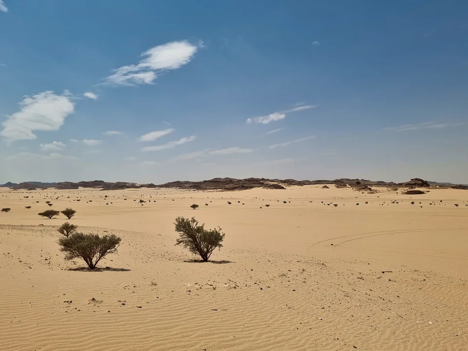

Hima Cultural Area in Najran connects three parts of Saudi heritage: water, travel and the marks people left on rock. Its wells help explain why journeys converged here; its inscriptions and images preserve evidence of people passing through at different times. Reading those elements together gives a richer understanding than treating every carved surface as an isolated attraction.
This guide answers a focused question: how do the wells, caravan setting and rock inscriptions relate to each other? It offers an original way to organize that evidence, with current official references checked on 3 October 2026. It does not translate inscriptions, date individual photographs or provide a confirmed visitor itinerary.
Place Hima within Najran's wider geography
Saudipedia's Hima account places the cultural area in Thar Governorate, approximately 130 kilometres north of Najran city. That is a geographical orientation, not a promised driving distance or journey time. Start with our Najran regional guide to distinguish the province from its principal city before planning an excursion.
Think in three scales: the city where you are based, the broader archaeological landscape, and the specific place you intend to see. A city map does not explain the boundaries of a heritage property. Equally, a photograph labelled Hima does not identify every nearby road, settlement or rock formation as part of the inscribed site.
Keeping those scales separate makes descriptions more useful. Write down a site's actual name alongside the name of the wider area. If a reference says only “near Najran,” retain that uncertainty rather than assigning the image to a precise component or inventing a route to it.

Begin with the wells and the journey
Saudipedia's historical overview describes Hima as a passage on an ancient caravan route and identifies its wells among the surviving archaeological features. Water supplies give a practical starting point for understanding movement through an arid landscape. A journey requires places to stop as well as places to reach.
Imagine recording a route as a sequence of needs: water, rest, onward direction and communication. This is a reading exercise, not a reconstruction of a particular caravan. It helps explain why a well and a written record can belong to the same historical question even when they are different kinds of evidence.
Ask what the official account establishes about the water point and what remains unknown about a particular traveller. A known route does not prove that everyone used the same itinerary, carried the same goods or stayed for the same duration. The value of the connection is that it gives you better questions to ask of the records, rather than a complete story to supply yourself.
Recognize a cultural area with several components
The UNESCO geographical record identifies six components: Hima Wells, Saidah, 'An Jamal, Dhibah, Minshaf and Najd Khayran. Its map register includes both the 2021 inscription maps and a 2024 minor boundary modification. Use the current record when discussing the property's extent; an older map may describe an earlier boundary.
“Serial property” means that the World Heritage entry brings separate components together. It does not mean that one viewpoint contains everything or that every component has identical arrangements for visitors. The names are a useful research checklist, not a recommendation to attempt all six in a day.
When comparing sources, check whether a figure refers to a component, the inscribed property, its buffer zone or the wider cultural landscape. Areas measured in hectares and broad landscape descriptions measured in square kilometres may have different scopes. Copying them into one comparison without those labels can create an apparent contradiction. This guide therefore uses component names without presenting a combined land-area claim.
Separate pictures, writing and interpretation
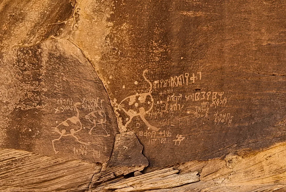
UNESCO's World Heritage description records rock images and inscriptions across a long historical span, including several writing systems. It dates the World Heritage inscription to 2021. Those statements concern the wider property; they do not date every mark on a photographed panel or identify its writer.
Make three columns in your notes: visible feature, published identification and open question. In the first column, describe a row of marks, a recognizable outline or where one feature sits relative to another. In the second, record only the identification supplied by a reliable source. In the third, retain uncertainties about date, language, purpose or the relationship between nearby marks.
For example, a photograph may show an animal-like outline beside writing. That proximity alone does not establish that one person made both, that both belong to the same period or that the text describes the figure. Translating the writing and interpreting its association require specialist evidence. An honest unanswered question is more useful than a vivid unsupported story.
Compare Najran's heritage without merging its histories
The Najran earthen-architecture guide offers another way to read the region: through buildings, form and setting. Hima introduces a different evidence base, centred on archaeological places and records on rock. Exploring both broadens the picture without assigning them a common age or purpose.
Our Hail rock-art guide concerns Jubbah and Shuwaymis in a separate part of Saudi Arabia. Use it for comparison, keeping the named sites, geography and source accounts distinct. A resemblance between two figures does not establish the same maker, date or meaning.
One useful comparison asks what each source allows you to know about movement. At Hima, start with the relationship between wells, routes and written traces. For another site, begin with its own official explanation. The comparison should sharpen each place's story rather than reduce all Saudi rock art to one generic desert experience.
Carry a better question into further research
Before arranging a visit, establish the precise component, current access arrangements and the guidance available from the relevant official heritage channels or visitor provider. A World Heritage listing supplies cultural context; it does not confirm today's opening hours, road conditions, admission arrangements or permitted activities. The photographs here document subjects, not current visitor access.
- Keep the well, route and inscription as related but separate pieces of evidence.
- Record the component name and the date of the reference you use.
- Distinguish what you see from a translation or specialist identification.
- Follow site instructions and observe surfaces without touching, tracing or changing them.
For broader everyday orientation, continue with our Najran city guide. Keep that practical context alongside the historical question. The strongest starting point for understanding Hima is simple: why did people stop here, and what evidence of their presence can we actually support?
Sources and review
- Saudipedia: Hima Cultural Area — reviewed 3 October 2026. Official Saudi Ministry of Media reference dated 30 January 2023; Thar Governorate and approximately 130 km north of Najran city. Not a driving distance or travel-time guarantee.
- Saudipedia: Why Hima was inscribed — reviewed 3 October 2026. Official account dated 18 February 2023; ancient caravan passage and wells as archaeological context. No reconstruction of an individual caravan.
- UNESCO: Hima geographical record and maps — reviewed 3 October 2026. Six named components and map register including the 2024 minor boundary modification. Areas, buffer zones and wider landscapes are not conflated.
- UNESCO: Hima World Heritage record — reviewed 3 October 2026. World Heritage inscription in 2021; rock images and multiple writing systems across a long historical span. No dating or translation assigned to a photographed panel.