
Al Wahbah Crater: Geology and a Thoughtful Visit
Discover Al Wahbah Crater in western Saudi Arabia, understand its volcanic origin and prepare a thoughtful visit with practical route and access checks.
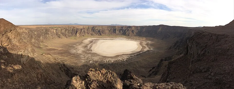

Al Wahbah Crater is a volcanic landscape in western Saudi Arabia where a broad, pale floor lies below steep rock walls. It rewards a visit built around understanding what you can see from the rim. For a first outing, plan the road journey and a viewpoint visit separately from any proposed descent, and confirm current access before leaving. A photograph of someone inside the crater does not establish that the same route is suitable or permitted today.
This guide answers a specific question: what makes Al Wahbah interesting, and how can you prepare a thoughtful visit? It complements our Makkah Region overview, rather than covering the region's cities, accommodation or property market. The geological descriptions below come from specialist sources; the planning checklist is our practical editorial guidance, reviewed on 3 October 2026.
A volcanic crater, not a meteorite impact
The International Union of Geological Sciences site record identifies Al Wahbah as a maar formed through an explosive interaction between magma and groundwater. Its published dimensions are approximately 2.3 kilometres across and 250 metres deep, with formation around 1.15 million years ago. These are rounded geological measurements, not walking distances or estimates of how long a visitor needs.
A maar is a volcanic depression created by that explosive process. The useful distinction is between the crater's origin and its present appearance: a large circular hollow alone does not prove a meteorite impact. A 2014 geological research paper describes older lava flows and a volcanic cone exposed in the crater walls. From a viewpoint, look for changes in colour and texture without assuming that every visible band represents the same material.
The IUGS record documents salt deposits beside an ephemeral lake photographed in May 2023. An ephemeral lake is temporary. A pale floor in one photograph and water in another therefore need not contradict each other. Neither image guarantees the surface conditions on the day of your visit.

Recognition without exaggerated claims
On 28 August 2024, Saudi Press Agency reported the Saudi Geological Survey's announcement that the crater had been selected among the geological heritage sites recognised for that year's international list. This is a dated recognition, not a new announcement in October 2026. The IUGS listing provides the specialist explanation behind the recognition.
Geological heritage recognition concerns the value of the landscape for understanding Earth processes. It should not be described as a booking confirmation, a guarantee of visitor services or a promise that every part of the site is accessible. Avoid turning a specialist listing into a claim about today's opening arrangements.
For a reader, the recognition suggests a better way to spend time here: observe the overall shape, compare the wall with the floor, then connect the view with the geological explanation. You do not need to collect rocks or reach the lowest point to learn something useful. Keep photographs and notes as your record, and leave the landscape intact.
Plan the journey before the viewpoint
Use the official Visit Saudi attraction listing as a starting point for identifying the destination. Then confirm the current approach, access instructions and any restrictions with the relevant operator or authority. A tourism listing identifies an attraction; it cannot replace a check of conditions for a particular day.
Build your itinerary backwards from the return journey. Record your intended arrival, time available at the site and latest departure that leaves a comfortable margin. A map pin is useful for locating a destination, but an app's journey estimate should remain an estimate. Allow for stops and changes in conditions rather than scheduling every minute around the shortest suggested drive.
Before setting out, resolve these practical questions:
- Which entrance or designated viewing area are you intending to reach, and who has confirmed that approach?
- Does the route information match your vehicle and the actual road you plan to use?
- Have you checked the local forecast and any official weather or access alerts for the travel window?
- Do you have water, suitable footwear, sun protection, navigation and sufficient fuel for the return?
- Does someone know your itinerary and the time you expect to be back?
Our Saudi travel and transport guide helps place a rural excursion within a wider journey. Read the climate and seasons guide for general context, then use current local information for the outing itself. National seasonal descriptions cannot tell you the temperature, visibility or wind at one exposed viewpoint.
Separate viewing from hiking
A rim visit and a descent are different plans. Before considering a hike, establish whether an authorised route is open, what supervision is appropriate and how the return will work. The crater's published depth is a reason to ask those questions; it is not a measure of a path's difficulty, gradient or condition.
For a mixed group, start with each person's needs. Someone comfortable with a long road journey may still need a short walk, an accessible viewing position or a shaded break. Confirm those facilities individually. Do not describe the whole attraction as accessible simply because vehicles can approach part of it.
Choose a stopping point where everyone can enjoy the view within the confirmed arrangements. Avoid moving towards an edge to fit more of the crater into a photograph. A wider lens or a more distant composition can preserve the relationship between foreground, walls and floor without making the photograph depend on a risky position.
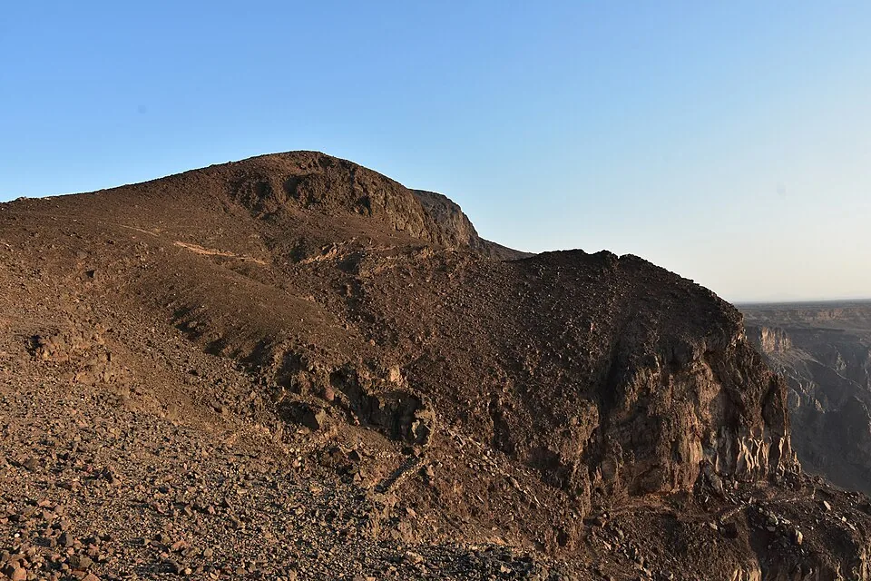
The real photographs in this article show different parts of Al Wahbah: the overall crater and a closer section of its rocky rim. They are credited landscape photographs, not a survey of current paths, barriers or facilities. Use them to recognise the subject and appreciate its form, not to reconstruct an unverified walking route.
Make the visit part of a coherent regional itinerary
If you are also considering Taif's mountain landscapes, read our Al Hada and Taif visit guide. Treat the mountain outing and the crater as separate destinations requiring their own route checks. Sharing a regional itinerary does not make them adjacent stops or guarantee that both fit comfortably into one day.
A useful visit has a clear purpose: perhaps landscape photography, an introduction to volcanic geology or a quiet viewpoint stop. Decide that purpose before adding extra activities. It helps you choose appropriate company, allow enough time and judge whether the confirmed arrangements meet your needs.
Afterwards, compare your observations with the specialist source rather than filling gaps with assumptions. Note what you actually saw, the visit date and any conditions that shaped your experience. That creates a more useful account for future planning than a universal claim that the crater is always dry, always open or easy for everyone.
Sources and review
- IUGS: The Pleistocene Al Wahbah dry maar crater — reviewed 3 October 2026. Rounded width, depth, formation date, magma-groundwater origin and documented temporary lake in May 2023; no current access guarantee.
- Saudi Press Agency: Geological heritage recognition — reviewed 3 October 2026. 28 August 2024 SGS announcement; explicitly dated historical recognition, not fresh news.
- Abdel Wahab et al.: Geology and geochronology of Al Wahbah — reviewed 3 October 2026. 2014 primary research abstract: older volcanic flows, dissected scoria cone and phreatomagmatic origin.
- Visit Saudi: Wahba Crater — reviewed 3 October 2026. Official destination listing; no current hours, facilities or routes inferred from its sparse rendered page.