
Uqair Port: Trade, Buildings and Maritime Heritage
Understand historic Uqair port through its Gulf setting, trade functions, columns, passages and mosque, with source-linked architectural context.

Historic Uqair port helps explain how the Gulf coast connected Al-Ahsa with the Arabian interior. Its significance becomes clearer when you read the site as a working sequence: goods arrived by sea, passed through port administration and continued overland. Buildings for trade, government, rest and worship belonged to that wider relationship. A photograph of columns can introduce the place, but understanding the connections between functions tells you much more than an isolated architectural detail.
This guide explains that maritime heritage through geography, building roles and careful observation. It is a cultural interpretation, with suggested exercises for readers, rather than a report of a visit. Sources were reviewed on 4 October 2026. Historical photographs illustrate their stated subjects; they do not establish present access, restoration completion, opening hours or road conditions. Keep those operational questions separate when deciding whether to travel.
Locate Uqair within Al-Ahsa and the Gulf coast
Saudipedia’s historic port reference, dated 20 October 2022, places al-Uqayr in Al-Ahsa Governorate, Eastern Province, Saudi Arabia. It describes the port as a maritime gateway serving Najd and the eastern region. That geographic relationship is the starting point: a coastal site can have a history shaped by destinations well beyond its shoreline. The coast, the oasis and the interior are connected parts of the explanation, without being interchangeable places.
Use the Eastern Province guide to establish the broader setting before concentrating on the port. Provincial geography helps you distinguish Uqair from Dammam, Al Khobar and inland Al-Ahsa landmarks. Being in the same province does not make them a single sightseeing district. Avoid borrowing driving times or directions from another attraction simply because its description also mentions the Eastern Province.
Spelling can complicate research. This article uses Uqair in its title and preserves al-Uqayr in the linked reference’s name. When another source uses a different transliteration, check its named governorate, coastline and landmarks before treating it as a separate place. Record the spelling alongside the source URL. That small habit prevents duplicated notes and makes later comparisons easier, especially when working between English descriptions and Arabic reports about العقير.
Follow the movement of goods through a port
A useful way to approach maritime heritage is to imagine a consignment rather than a monument. Something arrives, somebody handles it, an authority records or controls it, and another journey follows. This is an explanatory model, not a reconstruction of one documented shipment at Uqair. Its purpose is to connect the functions named in historical accounts and identify the questions those functions raise.
Begin with three stages: sea arrival, the port interface and inland movement. For each stage, ask what people, space and information were needed. Unloading needs an interface between vessel and land. Administration needs a place to process goods or people. Onward transport needs coordination beyond the waterfront. A building’s role becomes easier to understand once you place it in this sequence, rather than judging its importance only by size or ornament.
Then add time. A consignment could not be understood solely as an object moving across a map; people needed to wait, communicate and organise work. Resting places and social facilities therefore deserve attention alongside trade buildings. Do not invent an exact timetable, cargo quantity or labour arrangement. Leave such fields open until a specific record supports them. The model is valuable because it makes missing evidence visible instead of supplying an attractive but unsupported story.
Distinguish administrative buildings from other spaces
The Saudi Press Agency’s coastal heritage report, published on 14 October 2017, identifies customs, passports, a khan, administration, a fort, a mosque and other facilities in its account of Uqair’s development. It also records conservation attention to the historic buildings. These named functions provide a foundation for interpretation; they do not identify the original purpose of every opening, column or room visible in a photograph.
Separate a supported building label from an inferred activity. “Customs building” is a functional identification when attached to a reliable reference. “This particular window was where every trader paid” is a much narrower claim and needs different evidence. The same distinction applies to the khan: a reference to accommodation or rest does not establish the occupancy or use of each surviving chamber. Precise labels improve understanding when they remain precise about their limits.
If you sketch a simple relationship map, give the buildings different roles rather than different rankings. Administration concerns authority and records; rest concerns people and waiting; worship concerns another aspect of community life. A fort may add a further institutional dimension. This is a framework for asking how a port operated. It should not become a confident floor plan with invented room names or a claim that all the structures belong to one construction campaign.

Read columns, openings and passages carefully
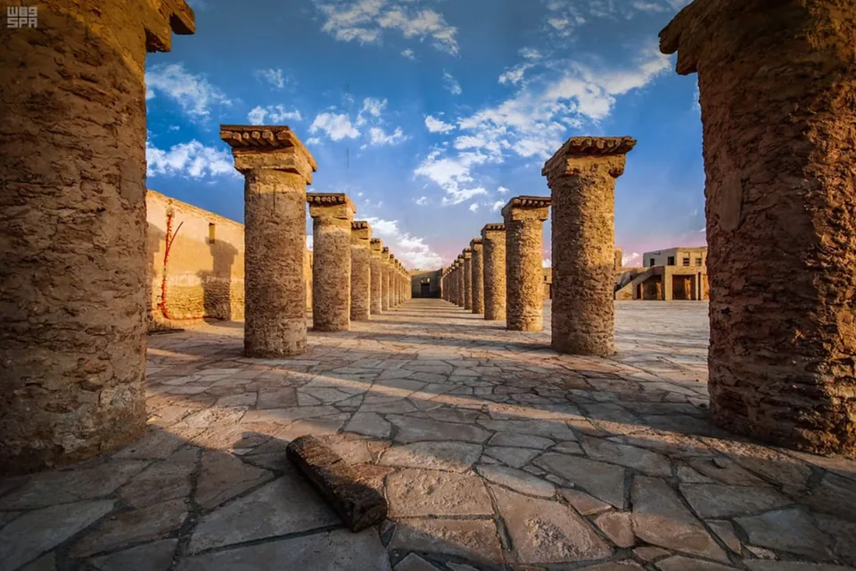
The cover photograph shows rows of stone columns and paving at Uqair port. Start with what it actually shows: repetition, spaces between supports, the ground surface and a view through the rows. You can describe those visible relationships without assigning a precise construction date or declaring which elements are original. The distinction keeps architectural observation useful even when the photographic record is more detailed than the available historical explanation.
Repetition can guide attention. Compare a near column with a distant one, noting how perspective changes apparent width and spacing. Look at the junction between support and top rather than calling every projecting element a decorative flourish. A photograph can suggest how a covered or organised space might be read, but it cannot by itself establish its earlier roof, loading practice or structural capacity. Those questions require records or specialist investigation.
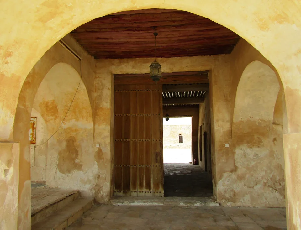
The passage photograph offers a different scale of observation: an arch, timber overhead and openings beyond. Follow the line of sight through the space and distinguish a doorway from a confirmed public route. Do not infer that visitors can pass through today because a photographer previously stood there. An interior image is evidence of a photographed view at a particular time. Its value here is to show a spatial relationship that a broad exterior view would miss.

Include worship and everyday life in the account
Maritime history becomes narrow when it only follows commodities and official decisions. The SPA report of 21 April 2022 names a mosque among Uqair’s historic landmarks. That reference makes it reasonable to include worship in the account of the port’s built environment. It does not establish a current prayer timetable, visitor entitlement or the age of every surface shown in the accompanying licensed photograph.
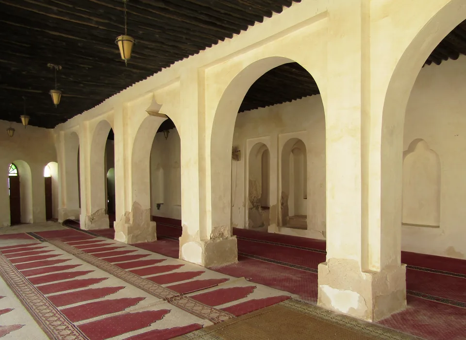
The mosque image shows an arcade, a timber ceiling and prayer carpet. Describe these as visible features rather than using them to manufacture a story about a named individual or ceremony. The photograph can help a reader notice how rows of arches frame an interior and how a carpet organises the floor. Any interpretation of movement should remain a suggested reading of the image, not a claim that this article has observed present worshippers.
Bringing everyday life into the account also changes your questions about the other buildings. Where might someone have waited between tasks? What sources would explain accommodation, food or communication? These are research questions, not claims about undocumented services. They make the history more human without turning uncertainty into anecdote. If a reliable account identifies a practice, connect it to its date and location; if it does not, keep the question open.

Connect the port with Al-Ahsa’s inland landscape
Uqair’s shoreline setting and Al-Ahsa’s inland landscape support different kinds of reading. At the port, the emphasis is on interfaces between maritime movement, administration and onward journeys. In the oasis, attention may turn toward cultivation, settlement and water relationships. Neither setting should stand in for the other. A photograph of palms cannot illustrate a specific port building, just as a port arcade cannot establish the layout of an oasis neighbourhood.
Read the Al-Ahsa oasis landscape article alongside this guide for that comparison. Keep two columns in your notes: what belongs to the coastal port question and what belongs to the oasis question. A reference connecting them is stronger than a vague statement that the entire region has one unchanging character. The relationship is worth understanding precisely because its places and functions differ.
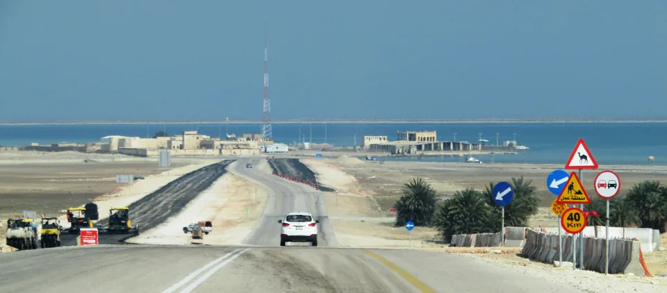
The coastal approach photograph illustrates another useful distinction. It shows a road descending toward the port and Gulf coast, with contemporary features visible in the image. It is not a map of a historical caravan route or proof of current travel conditions. Use it to understand the broad contrast between approach and waterfront. For an actual journey, check current directions and conditions separately; do not turn the photograph’s perspective into a recommended driving instruction.
Keep political history and architecture on separate timelines
A historic port connects a waterfront with the buildings and routes behind it. Read that connection at several scales: the shore where cargo could arrive, the spaces where goods could be handled, and the onward relationship with the oasis. These are useful questions for architectural observation, not a reconstruction of a particular shipment. A surviving facade cannot by itself establish the date, ownership or use of every room behind it; those details need identified historical evidence.
Maintain separate timelines for events, building work and conservation. An event date answers when something occurred. A construction date concerns a structure or phase. A restoration date concerns later intervention. Combining them into one label, such as “the building from the treaty year,” can silently introduce a claim that no source has established. Even a plausible relationship needs evidence before it becomes a factual statement in a caption or guide.
Understand conservation as part of the visible site
A heritage photograph may show historic fabric, repair and later intervention together. The SPA conservation account and Saudipedia reference make that an important issue at Uqair. A clean surface is not automatically evidence of recent construction, and a weathered surface does not establish an ancient date. Appearance can prompt a question, but it cannot provide a complete material history or certify the condition of a structure.
Respect the difference between interpretation and inspection. This cultural guide does not assess the safety of walls, ceilings or access routes. If you visit, follow current site instructions and keep to permitted areas. A photograph of an accessible-looking staircase or passage does not establish that it is open or safe today. For photographs and notes, a publicly permitted viewpoint can still reveal useful relationships without touching fabric or entering a restricted structure.
Build a short record that another reader can check
An effective evidence notebook separates identification, observation and interpretation. Identification records which place or object the source describes. Observation records something visible in a photograph or from a permitted viewpoint. Interpretation explains a possible relationship. Keeping those fields separate helps you correct a mistaken label without discarding everything else you noticed. It also makes your account easier for another reader to assess.
- Record the exact place name, source URL, source date and review date before summarising a historical claim.
- Describe the photograph’s actual subject and location, retaining the creator and licence alongside it.
- Mark suggested explanations as interpretations, and leave construction dates or room functions blank when unsupported.
- Keep current access questions in a separate planning note, with their own recent confirmation source.
For example, a column photograph supports an observation about repeated supports. The historical port account supports a relationship between the site and trade. Together they can motivate a question about the organisation of work, but they do not establish what happened beside each column. This example demonstrates why combining sources requires care. Evidence becomes stronger through a well-defined connection, not simply because several links have been placed next to a sentence.
Choose a focused next step
The most useful next step is to decide which question interests you most: the coastal setting, the relationship between port functions, or the building details. Choose one and read its evidence closely. A focused enquiry produces a clearer understanding than collecting landmark names without explaining how they relate. You can then return to the broader Al-Ahsa context with a better sense of what the port contributes.
For another Saudi maritime comparison, read Yanbu’s streets and Red Sea setting. Use the comparison to ask how two places express different coastal histories, rather than transferring a building label or route from one to the other. Check the exact location whenever you reuse a source or photograph. Comparative reading is most informative when the distinctions between places remain visible.
If a visit follows, confirm current access through an official or responsible site channel before setting out. This guide supplies a cultural framework and traceable historical references, not a booking service or an opening guarantee. Uqair becomes more intelligible when sea, land, administration and everyday life are considered together. Keep each claim attached to its evidence, and the port’s architecture can lead to a richer account than a picturesque collection of ruins.
Sources and review
- Saudipedia: Historic al-Uqayr Port — reviewed 4 October 2026. Historical reference dated 20 October 2022; port location and functions, not current access.
- SPA: Historic ports on the Kingdom’s coasts — reviewed 4 October 2026. Historical agency report dated 14 October 2017; built functions and conservation context.
- SPA: Uqair maritime gateway — reviewed 4 October 2026. Historical report dated 21 April 2022; coast and named landmarks, not current visitor operation.