
Al Qarah Mountain: Rock, Caves and Cool Interiors
Understand Al Qarah Mountain in Al Ahsa through rock forms, cave climate and visitor presentation, with source-linked context and practical access questions.
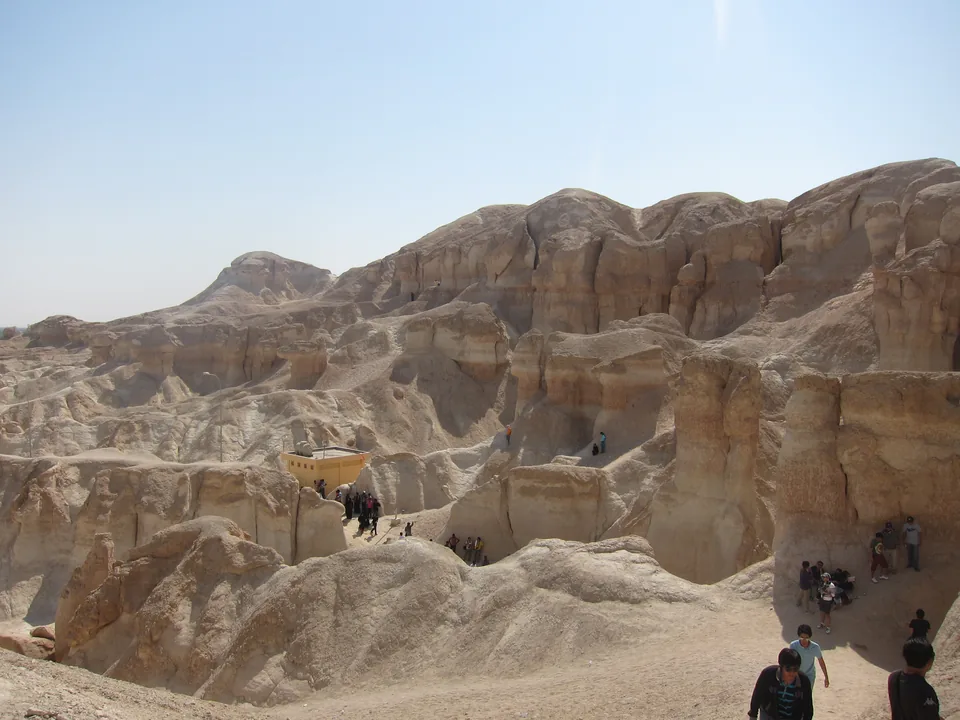

Al Qarah Mountain is a rocky landmark east of Hofuf in Al Ahsa, Saudi Arabia’s Eastern Province. Its appeal comes from the relationship between exposed rock, narrow passages, caves and the surrounding oasis. To understand it well, distinguish the natural landform from the managed visitor setting, and distinguish a cave’s reputation for coolness from a measured temperature at a particular time. Those distinctions make the mountain more interesting and a visit easier to plan.
This guide explains how to read the mountain’s visible features, what published descriptions establish, and what to confirm before travelling. It uses official historical references reviewed on 4 October 2026 alongside four licensed photographs. The photographs show different views, rather than a complete present-day route. Opening hours, admission prices and access to individual passages need current confirmation from the site; none is inferred from an older picture.
Place Al Qarah within the Al Ahsa landscape
Saudipedia’s Al-Qarah Mountain reference, dated 11 February 2021, locates the mountain east of Hofuf and describes layered rock, caves and nearby oasis settlements. English spelling varies between Al Qarah, Al-Qarah and Jabal Al Qara. Search results using these forms may refer to the same landmark, but check that the location is Al Ahsa. A similar name elsewhere in Saudi Arabia is not enough to establish a match.
The mountain supplies a useful change of scale when learning about the oasis. In a broad landscape view, palms and buildings form patterns across relatively flat ground. At the rock face, attention moves to surfaces, openings and the small spaces between them. A photograph focused on a ridge answers a different question from a photograph showing a farming landscape. Neither replaces the other, and neither should stand for the entire governorate.
Our Al Ahsa oasis landscape guide develops the wider relationship between water, cultivation and settlement. Use that context here without turning this mountain guide into a second oasis overview. The specific question at Al Qarah is how a rocky place can be understood through its visible form and its visitor presentation.

Read layers, columns and openings before naming processes
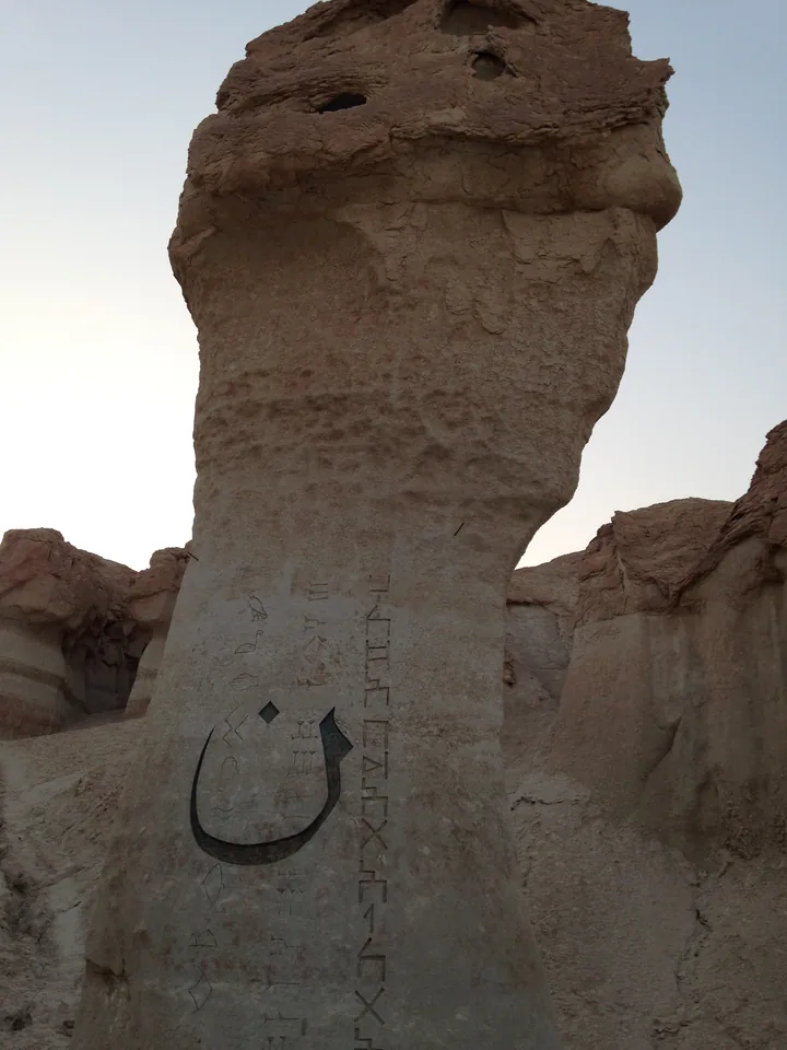
Begin with features that a view actually shows: a change in colour, a projecting upper surface, a narrower lower section, a dark opening or a line that continues across several faces. Describe the feature before assigning an explanation. A column may resemble an animal or a human profile, but that resemblance is an imaginative comparison, not a geological classification.
Saudipedia describes layered limestone and weathering at Al Qarah. Its short overview is useful orientation rather than a detailed survey of every exposed surface. A photograph cannot resolve the exact composition of each layer, the rate at which material was removed, or whether a particular opening follows a fracture. Those questions require geological observations and appropriate site-specific evidence.
Try a simple comparison using the cover photograph and the separate column photograph. In the broad view, follow the skyline and look for repeated shapes. In the closer view, compare the upper and lower portions of one feature. Record what remains visible in both: differences in width, surface texture and the direction of shadows. Do not add a formation age or an erosion rate that the images cannot establish.
This approach also helps when comparing descriptions online. Words such as sandstone, limestone and sedimentary are not interchangeable labels for any pale rock. If a source gives a broad description and a more technical study identifies several materials, retain their different levels of detail rather than silently merging them into one confident statement.

Understand why a passage is not a complete cave map
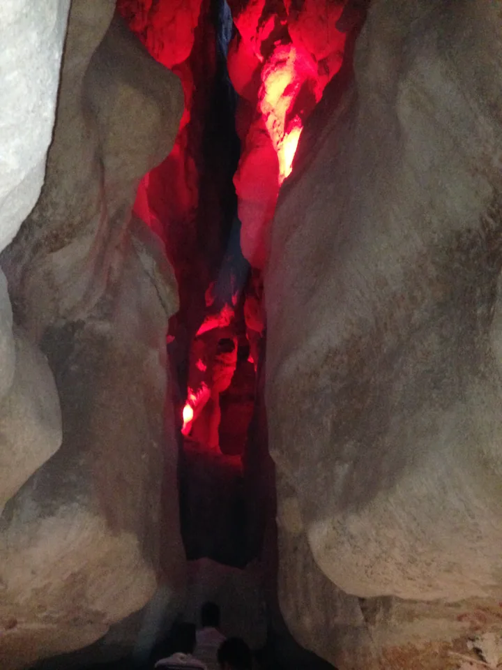
A narrow corridor can look long when photographed toward darkness, yet the picture may end at a bend just outside the frame. An opening might connect to another space, lead back toward daylight, or be closed to visitors. Width and apparent depth also change with camera position. The licensed passage photograph illustrates a particular visible space; it does not map the mountain’s entire interior.
Saudipedia’s national cave overview, dated 11 March 2021, distinguishes different cave settings, including sedimentary rock caves and lava tubes. That national context explains why the word cave alone does not identify one formation process. It should not be used to transfer the characteristics of a volcanic cave elsewhere in the Kingdom to every opening at Al Qarah.
For a reader, the useful distinction is between a photographed passage, a published description of a cave system, and a current permitted visitor route. These are three different kinds of information. A route may use only selected spaces, while a photograph may predate current management arrangements. Follow the route permitted on the day rather than treating an image sequence as instructions to explore.
If a guide names individual caves, ask how those names correspond to the route being discussed. Transliterations and local names can vary. A list of names is not a reliable way to infer that every named space is accessible, connected, equally spacious or suitable for the same visitors.
Interpret coolness as a local condition
Al Qarah is often described through the contrast between hot outdoor conditions and its cooler caves. That is an appealing introduction, but it becomes misleading when converted into a promise that every passage maintains one temperature throughout the year. Saudipedia’s historical account discusses cool interiors and seasonal variation. It is not a current temperature log for the precise place and time of a future visit.
For general physical context, the United States National Park Service explanation of cave climate, updated 27 August 2021, discusses how rock and airflow influence cave temperatures. It also notes greater variation near entrances. Its example is Lehman Caves in Nevada, not Al Qarah. The transferable idea is that cave conditions depend on their physical setting; Nevada’s measured temperature and humidity cannot be imported as Saudi measurements.
Think of an observation as a small record with several fields: date, approximate time, position, whether the space is near daylight, and whether the number came from an instrument or a person’s impression. “It felt cooler after entering” describes an experience. “This entire mountain stays at that temperature” is a much larger claim and requires much stronger evidence.
For planning, do not let the cool-cave reputation erase the outdoor portion of a visit. Arrival, waiting and movement between spaces can take place outside. Consider the current weather and your group’s needs when confirming the permitted route. A pleasant interior does not establish conditions across the whole visit.
Separate natural rock from visitor presentation
The passage photograph contains red artificial lighting. That lighting changes the visible colour of the rock and creates a strong contrast with darker surfaces. It can help show the shape of a narrow space, but it should not be described as proof of red minerals, lava, a natural glow or a historical lighting arrangement. The caption identifies the light because it materially affects how the scene is understood.
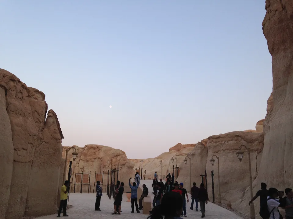
The walkway photograph shows a paved surface, lamps and people between rock walls. These visible additions are part of the pictured visitor environment. They do not establish when all the works were installed, which organisation currently operates them, or whether every adjoining passage has equivalent facilities. Avoid stretching one prepared area into a claim about the accessibility of the whole mountain.
Saudipedia records a cultural tourism initiative called Land of Civilizations and describes its partial opening in 2016. Treat that as dated development history. It does not provide today’s operating schedule, a complete list of current exhibitions or a guarantee that facilities mentioned in an older account remain unchanged.
When evaluating a place description, ask whether a sentence concerns the rock itself, an interpretation display, or an operating service. “A shaped rock face is visible” and “a visitor facility is available today” have different evidence needs. Keeping the distinction clear allows cultural presentation to add meaning without being mistaken for either geological proof or a live booking confirmation.
Connect the mountain to heritage without flattening boundaries
UNESCO’s Al-Ahsa Oasis description presents an evolving cultural landscape composed of multiple connected elements. Its account includes agriculture, water systems, settlement and natural features. This provides a useful framework for understanding why a rocky landmark should be considered alongside human activity rather than as scenery detached from the oasis.
The framework is broader than a tourist label. A place can contribute to the experience of a region without every nearby road, business, viewpoint or visitor installation having the same heritage designation. For an exact boundary question, consult the official property and buffer-zone maps. Geographic proximity and an attractive caption do not substitute for the boundary evidence.
For a different Eastern Province landscape relationship, the Uqair port maritime heritage guide examines buildings and coast through port functions. Comparing the two questions can enrich regional understanding: Al Qarah foregrounds rock and interior space, while Uqair foregrounds built maritime infrastructure. Their distinct settings should remain clear.

Confirm the parts of a visit that photographs cannot answer
Start with the official Visit Saudi Al Qarah Mountain page as a place-identification resource, then seek current confirmation of the practical details relevant to your group. Check the date and provider behind any booking or itinerary information you find.
- Confirm current opening arrangements, admission terms and any booking requirement for your intended date.
- Ask which spaces form the permitted visitor route and whether any part is temporarily restricted.
- Describe mobility needs specifically: step-free approach, surface changes, narrow sections and places to pause.
- Check facilities you rely on, including toilets, shaded waiting areas and arrangements for accompanying children.
- Keep the arrival plan separate from the route inside the attraction; an old road photograph is not a navigation update.
These questions turn a general attraction description into a plan that fits the actual group. Asking whether a place is “accessible” may produce a vague answer. Asking whether the currently offered route includes steps or narrow passages is more actionable. Likewise, the presence of paving in one historical photograph is insufficient to resolve the entire journey from arrival to exit.
Make a useful observation record
A short observation record can deepen the experience without requiring geological expertise. Choose a permitted stopping place and record the scene in plain language: what surface is visible, where daylight enters, what human additions appear, and what remains outside the frame. Keep people’s passage clear and avoid touching or altering the rock for a better picture.
Organise the record into observation, interpretation and follow-up. An observation might identify a horizontal band continuing across a face. An interpretation might suggest that this reflects a layer. A follow-up asks which geological description supports that suggestion. This preserves curiosity while preventing an impression from hardening into an unsupported fact.
For photographs, include a wide view and a detail if photography is permitted. The wide view keeps the detail in context; the close view makes texture easier to inspect. Name the place and describe the subject precisely when sharing the images. Do not label a coloured-light interior as if it shows the rock under daylight, or describe a historic photograph as evidence of current facilities.
When preparing a family or classroom discussion, use one question per image. The broad landscape image can prompt a skyline comparison. The column can prompt a shape description. The passage can prompt a discussion of light. The walkway can prompt identification of natural and constructed elements. These are learning exercises, not a prescribed route through the attraction.
Questions readers often ask
Is Al Qarah a natural landmark or a developed attraction? The rock landform and caves are the natural setting; the photographs and dated references also show or describe visitor presentation. Understanding both gives a fuller account. It does not mean that every constructed element is ancient or every natural space is open to visitors.
Can the caves be assumed to be cool enough for every visitor? The published reputation for cooler interiors is useful context, but it is not a personal comfort guarantee or a present measurement. Conditions near entrances and along an outdoor approach may differ. Confirm the offered route and consider current weather rather than planning around a single unsourced temperature.
Does the article give a climbing or independent exploration route? No. It explains visible features and evidence, with current route questions to ask before visiting. Stay within permitted areas and follow site instructions. A rock shape or a dark opening in a photograph is not an invitation to leave the managed route.
What should I read next? Use the Eastern Province overview to place Al Ahsa within the region, then select the specific oasis or port guide that answers your next question. Keep the mountain’s identity precise: a distinctive rocky place within a living regional landscape, understood best through observation, dated sources and current confirmation of access.
Sources and review
- Saudipedia: Al-Qarah Mountain — reviewed 4 October 2026. Historical reference dated 11 February 2021. Location, layered rock and cave character; no present opening hours or precise temperature promise.
- UNESCO: Al-Ahsa Oasis — reviewed 4 October 2026. Current primary World Heritage description reviewed 4 October 2026. Oasis landscape context, not a blanket boundary claim.
- Saudipedia: Caves in Saudi Arabia — reviewed 4 October 2026. Reference dated 11 March 2021; cave types and national geological context, not a technical diagnosis of each Al Qarah passage.
- National Park Service: Airflow and Cave Climate — reviewed 4 October 2026. Updated 27 August 2021; general cave-climate principles illustrated at Lehman Caves, Nevada. No Nevada measurement transferred to Al Qarah.